Paths Through The Wilderness
Adapted From the Don Ross Article


Paths Through The Wilderness
Adapted From the Don Ross Article


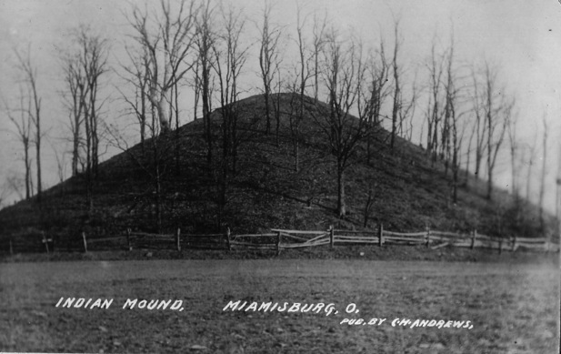
From approximately 100 B.C. to 600 A.D. the Hopewell Indians, known as the "Mound-Building Indians, occupied portions of Warren County, constructing earthworks and stoneworks up to 25 feet in height.
The most renowned of their nearby areas is Fort Ancient, just east of Lebanon, but the tribe were hunter-gathers, roaming throughout the area.
Around 1200 A.D. the group known to historians as the Fort Ancient Indians re-occupied the Hopewell sites. They were primarily farmers, but after a few centuries, they too receded.
When the first Europeans arrived to explore the territory, the Indian peoples occupying the land had no knowledge of their predecessors. Although no current history supports it, a large number of Clearcreek Township residents of the late 1800s remember stories of their grandparents that the}re was a large Indian settlement east of present-day Springboro, on the high ground along Route 73. There is some substance to the story; an inordinate number of Indian artifacts, particularly "points" -- arrowheads and spearheads-- are still being found in a broad area from Route 73 to the banks of Clear Creek.
Two treaties affected all of the Indians in the Ohio Country. The Treaty of Fort McIntosh (1785) deeded certain areas to the Ohio tribes for hunting and fishing. The Treaty of Greenville (1795) effectively relegated them to restricted territories and ended hostilities between them and early settlers.
Americans had taken control of the territory after George Rogers Clark and his troops defeated the British at Vincennes, Indiana in 1779. Virginia and Connecticut retained reservations of territory in what would eventually become Ohio.
Nine original major land surveys subdivided Ohio lands. The "Between the Miamis" survey delineated the Clear Creek Valley. William Henry Harrison introduced legislation in Congress to establish federal land sales offices in 1800. That set the minimum quantity of land that could be, purchased at 320 acres, at a fixed price of $2 an acre. One-quarter of the amount was due as a down payment, with three annual installments due afterwards, at 6 per cent interest. Defaults ran as high as three in ten.
Settlers had already entered the Clear Creek area by that time. The earliest were here by 1796, barely months after the Treaty of Greenville. In 1797 the Clearcreek Baptist Church near present-day Ridgeville became the first church in Warren County. A year earlier a settlement had been established around Red Lion. Other early concentrations of settlers occurred at Pekin and Utica. Ridgeville was officially platted in 1814 and Springboro in 1815.
Clearcreek Township was created in October of 1815 from portions of Franklin and Wayne Townships, two of the original four political subdivisions in Warren County.
(Until about 1850, Springboro and township residents travelled to Ridgeville to vote!)
Warren County, named after General Joseph Warren, who was killed at the Battle of Bunker Hill, had been established in 1803 as one of Ohio's original 17 counties. Part of the Northwest Territory, Ohio became the 17th state in the Union as part of the Northwest Ordinance of 1787.
What attracted the early settlers? Gently rolling hills, woods, an abundance of wildlife, and water.
They created paths through the wilderness, literally and figuratively.
(Excerpted and adapted from “Paths Through The Wilderness”, by Don Ross.)

Five miles northwest of Springboro is an “Indian Mound” attributed to the Hopewell Cultures, 200 BCE to 500 CE. A second mound is approximately three miles due west on the old Kinder farm, between Pennyroyal Rd and Franklin Rd.